In this guide
The Tizi n'Tichka is the High Atlas pass on the N9 road between Marrakech and Ouarzazate, peaking at about 2,260 m. The full 200 km route takes roughly 3.5–4 hours of driving without stops. The road is paved and has been widened in recent years, but it is winding, can close temporarily for snow between December and March, and should not be driven at night.
Key Facts at a Glance
| Item | Detail |
|---|---|
| Road | N9, Marrakech to Ouarzazate |
| Summit altitude | About 2,260 m (7,400 ft) |
| Total distance | About 200 km |
| Driving time | 3.5–4 h without stops; 5–6 h with photo breaks |
| Built | Modern road opened by the French in 1936, on an ancient caravan route |
| Main risks | Hairpins, trucks, fog, ice and snow in winter, rockfall after storms |
The Route Section by Section
Distances are approximate, counted from Marrakech.
- Marrakech to Aït Ourir (km 0–37): a flat run across the Haouz plain, with olive groves and the Atlas wall ahead. About 45 minutes.
- Aït Ourir to Taddert (km 37–90): the road enters the Zat valley foothills, climbing through red earth hills, oleander riverbeds and villages. Taddert, at about 1,650 m, is the traditional lunch and tea stop with grill restaurants.
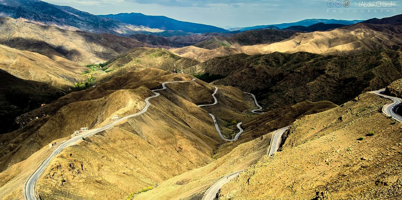
- Taddert to the summit (km 90–110): the steepest part, with the classic hairpins. Vegetation thins to juniper and bare shale; views open north over the switchbacks.
- Summit to the Telouet turn-off (km 110–130): a short descent through a high, barren landscape to the junction with the road to Telouet.
- Telouet turn-off to Aït Benhaddou (km 130–170): the landscape turns pre-Saharan, with ochre earth, fortified villages and palm-lined wadis.
- Aït Benhaddou to Ouarzazate (km 170–200): a straight final stretch past the film studios to the city.
Best Stops and Viewpoints
- Taddert: the village where most drivers stop for tea or breakfast before the steep climb.
- Hairpin viewpoints below the summit: several pull-outs give the famous view of the road coiling down the mountain. Stop only where there is room off the carriageway.
- The summit: a sign marks the col at 2,260 m, with stalls selling fossils, geodes and minerals. Be aware that some brightly coloured geodes are dyed; ask and compare prices.
- Irherm n'Ougdal: a village south of the pass with a restored communal granary (agadir), worth a short stop for architecture enthusiasts.
- Aït Benhaddou: the UNESCO-listed ksar, covered in our detailed Aït Benhaddou guide.
The Telouet Detour
At the junction south of the summit, a side road runs about 20 km east to Telouet, the former stronghold of the Glaoui family, who dominated southern Morocco in the early 20th century. The kasbah is largely ruined outside, but several reception rooms retain spectacular carved cedar ceilings and zellij tilework; a small fee applies (roughly 20–30 MAD, approximate). The detour adds about 1.5 hours including the visit. From Telouet, an older road follows the Ounila valley down to Aït Benhaddou via Anemiter; it is now paved for most of its length but narrower than the N9 and best done with a driver who knows it.
Is the Tichka Pass Dangerous?
For a careful driver in daylight and good weather, no. The road has been largely rebuilt and widened, with new passing sections and guard rails along much of the route. The genuine hazards are:
- Heavy trucks and buses climbing slowly; overtaking on blind bends is the most common cause of accidents.
- Night driving: no lighting, animals and pedestrians on the road, and oncoming vehicles with poor lights. Plan to be off the pass before dark.
- Winter weather: snow and ice can close the pass for hours or occasionally a day or two between December and March; police checkpoints at Taddert and Toufliht regulate traffic when conditions turn bad.
- Storms and rockfall: heavy autumn or spring rain can bring stones and mud onto the road.
- Motion sickness: the hairpins are relentless for about an hour; sit at the front, look at the horizon and take remedies before departure.
Driving Yourself vs Using a Driver
Self-driving is permitted and popular with confident drivers. Expect frequent police speed checks (limits drop to 40–60 km/h through villages), and fill up in Marrakech or Aït Ourir; fuel stations thin out towards the summit. If you would rather enjoy the views than watch the hairpins, a local driver makes a real difference. Our comparison of private and shared tours from Marrakech explains the options, and the overview of Marrakech day trips shows where this drive fits among other excursions.
When to Drive the Pass
| Months | Conditions at the summit | Notes |
|---|---|---|
| Mar–May | 5–15°C, snow on peaks | Green valleys, best scenery |
| Jun–Aug | 15–25°C | Cooler than Marrakech; heavy traffic in August |
| Sep–Nov | 8–18°C | Clear air; occasional storms |
| Dec–Feb | Often below 0°C | Check closures before leaving |
Frequently Asked Questions
How long does Marrakech to Ouarzazate really take?
Without stops, 3.5–4 hours. With a tea break at Taddert, photos on the hairpins and the summit, plan on 5 hours, and 6–7 hours if you add Telouet and a full visit of Aït Benhaddou.
Is there a tunnel planned?
A tunnel under the Tichka has been discussed for many years as a way to shorten the crossing and avoid winter closures, but for travellers in 2026 the N9 over the pass remains the route to plan on.
Can I cross the Tichka in a normal car?
Yes. The whole N9 is paved and any rental car handles it in dry conditions. In winter, carry warm clothes and water in case of delays, and follow police instructions at the checkpoints; snow chains are rarely needed but closures are possible.
Is there mobile coverage?
Coverage is good on most of the route, with short dead zones in the steepest sections below the summit. Download offline maps before leaving Marrakech.
Where are the fuel stations?
Fill up in Marrakech or Aït Ourir. There are a few stations on the climb and again on the southern side towards Ouarzazate, but opening hours in the mountain villages can be irregular.
Crossing the Tichka with Us
Our Aït Benhaddou and Ouarzazate day trip over the Tizi n'Tichka takes about 12 hours and starts from €40 per person, with free hotel or riad pickup, experienced mountain drivers and photo stops at the main viewpoints. We monitor conditions in winter and reschedule if the pass is closed. See all our Marrakech excursions, or message us on WhatsApp to add the Telouet detour on a private departure.
Comments